This image bring home just what it is like when rivers overflow their banks and make everyone's life a misery:

Here is an aerial view of Dresden. The old town is in the upper part of the photo. There should be a quay running alongside the river but this is all under water. The boats are anchored where the edge would normally be. if it get smuch higher it will flood the city:

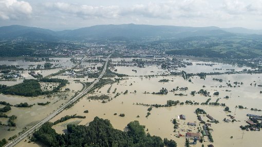
They say that it some areas the flooding is as high as it has been in the last 500 years. Meissen, Halle, Magdeburg, Dresden: many town are feeling the effects of these floodwaters. This photograph shows a motor way down near Munich:

There has been flooding in other countries too: Hungary and the Czech Republic. Here is a more dramatic photograph of what flooding can do:
All that water eventually disperses, following natural water courses until it reaches the sea. The main rivers in this area are the Elbe and the Danube. For Kaiserswerth this is good news because of course we are on the Rhine.
However. . .
Melting snow in the Alps (where the Rhine is born); heavy rains in southern Germany (through which the Rhine runs), and some run off from the flooded areas, has meant that the Rhine too has risen. This is view outside the old village walls, which you can just see on the right of this photo. The trees grown on a little beach area by the river :

The Flood water (hochwasser) signs are out to prevent us taking the river path to nearby Wittlaer. . .

. . . And everyone wanders down to the river to see if it is getting 'too' high for our liking. There is talk that the town flood barriers were to be prepared!

We often gauge the river's height by the angle of the gangway down to the pontoon for the Dusseldorf ferry. It should run at roughly a 30 to 35 degree angle. As you can see, that is not the case at the moment:

You should be able to walk to the marker, and on the far side of the river you can see that the ferry is staying where it is. The river is too fast for it to make the journey to our side.

Mind you, it isn't as bad as it could be. In 1926 the river rose 11 metres and Kaiserswerth was completely flooded. The only way to move around was by boat:

In 1993 and 1995 the river rose to at least 10 metres.
Thankfully in our time here I have not witnessed flooding to that extent, but we do get a rise in the water table when the Rhine is high. This week we have had the old river bed near our apartment suddenly begin to fill with water:

The ducks love it of course and we have seen duckling floating about in the fields. But it is not good for the horses and I read that coming at this time, the flooding has been particularly bad for the wild animals, with many nesting birds losing their eggs and young, and many baby animals drowning.
Here is another view of our rising water level. This is the pathway that wends it way around the bushes in the part of the old river bed below our apartment:

The fields are sodden and the grass (which the farm horses and cows would normally be frolicking in) is ruined:

Thankfully we are protected by our tree lined dykes. The main dyke runs from Kaiserswerth, all the way into Dusseldorf; providing a stout barricade as well as a nice car-free path for walkers, joggers, and bike riders. A smaller series of dykes protects our village. Trees were planted on top to stabilize it. Our own bijou apartment building sits atop the dyke too!

We feel that we are quite safe from any potential water threat.
Today when I checked the river I felt certain that it is receding...


